- In an astronomical almanach for amateurs, you may find:
- With an astronomical computer program you can find the following values:
| date | rectascension | declination | |
|---|---|---|---|
| Jupiter | December 5th | 4h14min | 20.3° |
| December 10th | 4h11min | 20.2° | |
| December 9th (calc.) | 4h11min | 20.2° | |
| Saturn | November 30th | 3h40min | 17.2° |
| December 15th | 3h35min | 16.9° | |
| December 9th (calc.) | 3h37min | 17.0° |
You can find the calculated values by linear interpolation.
| rectascension | declination | |||
|---|---|---|---|---|
| Jupiter | 4h11min 4.7s | 62.770° | 20°10'51" | 20.181° |
| Saturn | 3h36min28.7s | 54.120° | 17°00'55" | 17.017° |
- Measurement of the angular distance between Jupiter and Saturn:
- Calculation of the angular distance between Jupiter and Saturn:
- For the use of Pythagoras' theorem, you have to take into account the spherical kind of the coordinates by multiplying the rectascension alpha by the cosine of the declination delta.
- Using spherical trigonometry, you have to use the "theorem for the cosines of sides" ("Seitencosinussatz", in German, I don't know the English terminus!):
The angular distance d can therefore be calculated by
By this way, you will get the following result:
| cos(d) | = | cos(90°-deltaJ)*cos(90°-deltaS)+ |
| sin(90°-deltaJ)*sin(90°-deltaS)* cos(alphaJ-alphaS) | ||
| = | sin(deltaJ)*sin(deltaS)+ | |
| cos(deltaJ)*cos(deltaS)*cos(alphaJ-alphaS) |
Using this formula, you get the following result:
i.e., with an accuracy of about one promille, the same result as above!
.jpg) |
.jpg) |
| Koblenz | Namibia |
|---|
With an arbitrary graphic program (PhotoStudio, for instance),
you can determine the pixel coordinates of Jupiter, Saturn and the moon:
|
|
|
|
||
|
|
|
|
|
|
|
|
|
|
||
|
|
|
|
||
|
|
|
|
|
|
|
|
|
|
||
|
|
|
|
Therefore, the scales of the pictures are:
| Koblenz | 0,0257 o/Pixel |
| Namibia | 0,0211 o/Pixel |
|
|
|
|||
|
|
|
|
|
|
|
|
296,59 | 7,62 | 115,11 | 2,96 |
|
|
334,48 | 7,06 | 108,91 | 2,30 |
- With ruler and compasses:
You can draw the either triangles into the same drawing scaled 1o/ cm, for instance.
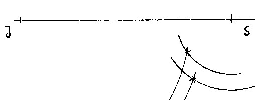
This construction is in good coincidence with the combinated picture in our evaluation document.
By measuring the distance of the either positions of the moon one gets the following result:
The moon's parallactic displacement due to Koblenz and Namib desert:
1,2°