
Diese Seite auf deutsch 
Measuring the Sun's position above the horizon
Simplified evaluation procedure
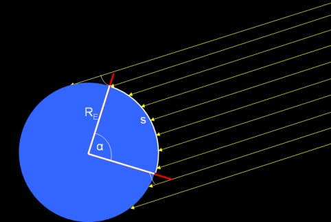
If you find two observation sites the direct connection of them is contained in a plain which also contains the direction of the sun light deriving the earth's radius is a plane problem. In this case, the central angle α corresponding to the arc between the both sites (that is a great circle on the earth's surface or a "orthodrome") is simply the difference between the simultaneously measured altitudes h1,2 of the sun.
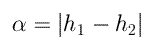
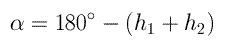
If the observers live on different hemispheres (to be more exact: north and south of the sub-solar point) this equation must be replaced by
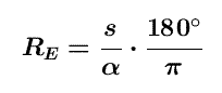
Now, if the distance s is known the radius can easily be calculated:
In praxis, there are only two realistic possibilities for such a situation:
- The both observers live on the same longitude and measure the position of the sun exactly at local noon.
- If one of the sites is the sub-solar point the simple situation is true for any other site on earth. That's the reason for refering to a well-known sub-solar point.
In this project, the sub-solar points for the three points of time are given. If you would like to repeat this experiment later you can determine the actual position (φss,λss) of this point for the time t0 by measuring your actual noon data (tM,hM):
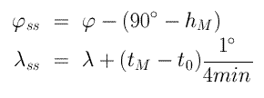
Obviously, you must know your own geographical position (φ,λ).
In all other cases, the situation is skew and a more sophisticated method is necessary for which we wrote a little program. We describe the algorithm in the document attached to this program.
back to the project page

 Udo Backhaus

last change: last update: 2020-03-03